


本文
Ehime in Japan, Ehime in the World
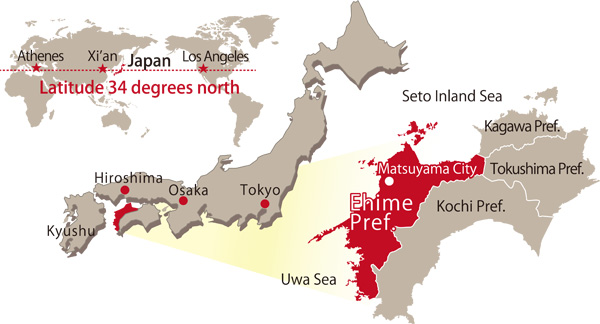
Ehime Prefecture is located in the northwest of Shikoku Island, one of the major islands in the Japan archipelago, and is at the same northern latitude of 34 degrees as Los Angeles and Xian.
The prefectures of Kagawa and Tokushima are to the east and Kochi Prefecture is to the south. Ehime faces Hiroshima to the north across the Seto Inland Sea and Kyushu to the west across the Uwa Sea.
The distance to Tokyo is approximately 680 am,an 80 minute flight; Seoul is about 670 km,a 100 minute flight; and Shanghai is about 1,100 km,also a 100 minute flight.
Bountiful Nature
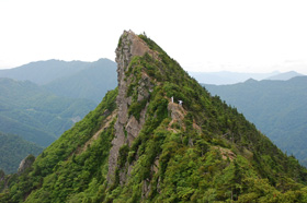
Facing the Seto Inland Sea and the Uwa Sea, Ehime Prefecture is blessed with a variety of nature; open fields, basin-shaped valleys, mountains, rivers and hot springs. The coast of the Seto Inland Sea is dotted with many islands both large and small and is sometimes called the Eastern Aegean Sea. It has been designated as the Seto Inland National Park. The coast of the Uwa Sea, with its deeply-indented coastline, is designated as the Ashizuri Uwa Sea National Park. In the central part of Shikoku is a mountain range with Mt. Ishizuchi as the highest peak. This range also contains the Shikoku Karst.
Mild Climate
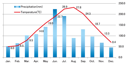
At a northern latitude of 33.50 degrees, Matsuyama City at the center of Ehime Prefecture is in a temperate zone. Ehime has a mild climate but not a lot of rain, with the average temperature of 16 degrees Celsius, and an annual precipitation of 1,300 mm. It has relatively high precipitation from June to September due to the rainy season and tropical storms, but from late September to February it has many consecutive sunny days. The relatively flat land at lower elevations has hardly any snow accumulation even in winter time.
Ehime Prefecture has been enriched with both the coastal areas of the Seto Inland Sea which has few tropical storms or earthquakes, and the Uwa Sea which has the wealth of the Japan Current from the south. From long ago, the prefecture has enjoyed the riches of the land and the sea and the resulting feeling of calm, the best kind of environment for business and daily life. It has the infrastructure to enable residents to enjoy sport and leisure throughout the year; for example wind surfing, golfing, skiing, and hiking that will enable you to feel the change of seasons in a natural environment.
|
|
Items |
Jan. |
Feb. |
Mar. |
Apr. |
May |
Jun. |
Jul. |
Aug. |
Sep. |
Oct. |
Nov. |
Dec. |
|---|---|---|---|---|---|---|---|---|---|---|---|---|---|
|
Average temperature (°C) |
16.5 |
6.0 |
6.5 |
9.5 |
14.6 |
19.0 |
22.7 |
26.9 |
27.8 |
24.3 |
18.7 |
13.3 |
8.4 |
|
Average maximum temperature (°C) |
20.8 |
9.8 |
10.6 |
13.9 |
19.4 |
23.6 |
26.8 |
30.9 |
32.1 |
28.6 |
23.3 |
17.8 |
12.6 |
|
Average minimum temperature (°C) |
12.5 |
2.3 |
2.5 |
5.2 |
10.0 |
14.7 |
19.1 |
23.5 |
24.2 |
20.8 |
14.5 |
9.2 |
4.5 |
|
Average humidity (%) |
67.0 |
63.0 |
63.0 |
64.0 |
63.0 |
66.0 |
72.0 |
72.0 |
69.0 |
71.0 |
68.0 |
67.0 |
64.0 |
|
Hours of sunshine (h) |
2,017.1 |
125.8 |
138.9 |
166.7 |
189.0 |
198.5 |
160.2 |
192.9 |
221.9 |
165.0 |
177.3 |
144.4 |
136.5 |
|
Precipitation (mm) |
1,314.9 |
51.9 |
65.6 |
102.3 |
107.8 |
141.5 |
223.6 |
191.6 |
89.6 |
130.3 |
96.7 |
68.0 |
46.0 |